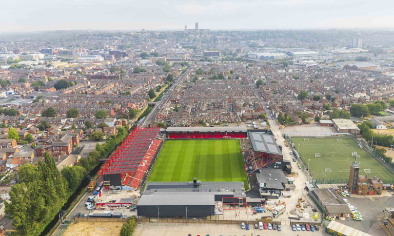
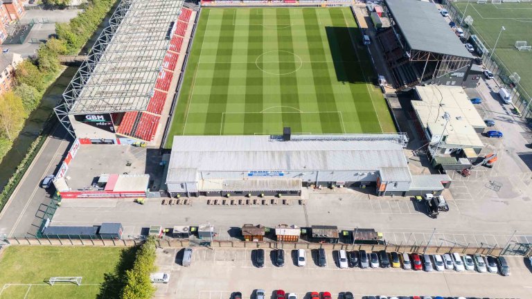
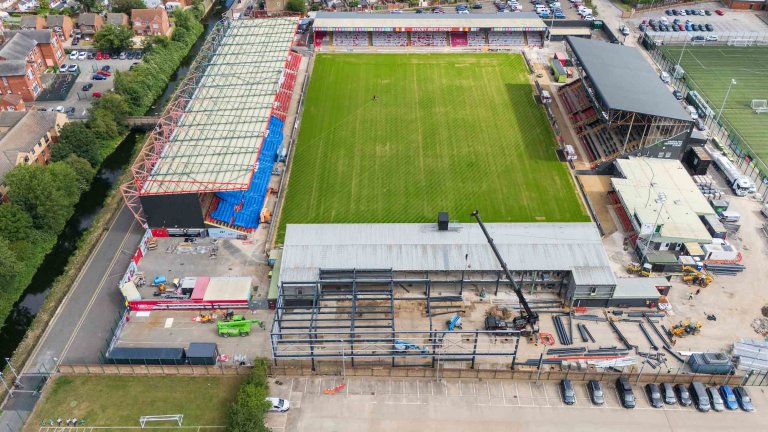
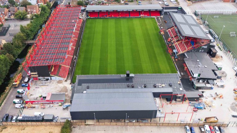
Rather than simply showing the finished result, the footage will allow viewers to experience the build developing from one stage to the next.
That is where planned drone photography becomes more than a record of a construction site.
It becomes the raw material for telling the project’s complete story.
Why consistency matters in construction progress photography
If every visit produces photographs from completely different positions, it can be difficult to compare one stage with another.
The images may all look impressive, but the viewer has to work hard to understand what has changed.
Repeating the viewpoint creates a visual reference point.
The surrounding stands, pitch, buildings and site boundaries remain broadly familiar while the work within the construction area develops.
This allows the audience to recognise changes quickly:
New structures have appeared
Groundworks have advanced
Materials have moved
Areas have been completed
The shape of the finished development has become clearer
Consistency does not make the photography repetitive.
It makes the transformation understandable.
The same principle applies to video. Repeating a flight route creates continuity between visits. As one pass moves into the next, the site changes while the movement and wider context remain familiar.
The consistency of the camera helps reveal the scale of the change.
Photography with an immediate and long-term purpose
Every weekly visit creates images that can support communications while the construction work is underway.
The photographs might be used for website updates, social media, internal communications, presentations or project announcements.
They give people who cannot visit the site a clear view of current progress.
However, the photography also has long-term value.
Once the build is complete, the collection can support:
A final project case study
A transformation video
Press and publicity around the completed development
Presentations about the redevelopment
Club history and archive material
Future partnership or sponsorship communications
Award entries
Marketing connected to the completed space
This combination of immediate and future use makes planned progress photography particularly valuable.
The images are not being created for one social-media post and then forgotten. Each visit contributes another stage to a growing visual story.
The value of drone photography is context
A ground-level photograph can show an individual section of a build in detail.
It may reveal the people working on the project, the materials being installed or a particular part of the structure.
What it cannot always show is how that section relates to everything around it.
An aerial photograph can reveal:
The overall scale of the construction area
How the project fits within the existing ground
The relationship between different sections
Access routes and surrounding buildings
Visible progress across the whole site
The changing footprint of the development
This wider perspective is particularly useful for audiences who are not familiar with the site.
It can make a complicated redevelopment easier to understand without requiring lengthy technical explanations.
The value of the drone is not simply that it flies higher than a conventional camera.
Its value is that it gives the project context.
Choosing the right construction milestones
Not every construction project needs to be photographed every week.
The appropriate frequency depends on the speed of the work, the scale of the development and how the images will be used.
For the Imps Territory build, the pace and significance of the summer redevelopment make regular visits valuable. Weekly coverage allows us to record incremental changes and create enough continuity for the eventual transformation film.
Other projects may benefit from photography at selected milestones, such as:
Before work begins
Completion of groundworks
The appearance of the main structure
Completion of major external works
Installation of important features
Practical completion
The finished and occupied development
The important question is not how often the drone can be flown.
It is when a new visit will contribute something meaningful to the story.
A well-timed sequence of six visits could communicate more than twelve photographs taken when very little visible change occurred.
Our approach is built around the project’s needs rather than automatically recommending the highest possible number of visits.
Repeatable video adds another layer to the story
Still photographs are excellent for showing detail and allowing audiences to compare particular stages.
Video provides a different experience.
A planned drone pass can move through the site, reveal its scale and guide the viewer from one area to another.
Repeating that route throughout the project makes it possible to create a transformation sequence in which the development changes around the viewer.
The effectiveness of the finished video depends on the consistency of the individual flights.
The route, direction and camera movement all need to feel connected. Construction activity, safety requirements and the changing site still need to be considered on every visit, so the flight cannot be repeated without assessing the conditions each time.
There may also be natural visual differences between visits. Weather, light, machinery and site activity will change.
Those variations are part of the reality of documenting a live construction project.
The objective is not to make every visit identical. It is to create enough visual continuity for the viewer to follow the transformation clearly.
Planning around a live construction environment
A construction site does not remain static between photography visits.
New structures may affect visibility. Plant and machinery may move. Access arrangements can change, and people may be working in areas that were previously clear.
Every flight must therefore be reviewed and completed safely and legally according to the conditions on the day.
Planning includes understanding:
Current activity on the site
Changes since the previous visit
Suitable take-off and landing areas
People, buildings and machinery nearby
Weather and visibility
Airspace requirements
The intended photographs and video route
Any site restrictions or operational priorities
The desire to recreate a previous viewpoint does not override safety.
If the environment has changed, the operation may need to be adjusted. Clear communication with the project team helps us understand what is happening and find the safest way to continue the visual sequence.
This is why construction drone photography works best as a partnership.
The site team brings detailed knowledge of the project and current operations. We bring photographic planning, visual consistency and responsible drone operation.
Creating more than a record of the site
Construction progress photography can easily become purely factual.
A photograph is taken to prove that a particular stage has been reached.
That can be useful, but marketing and communications imagery should do more.
It should help audiences feel the scale of the work, understand the ambition behind it and recognise the progress being made.
The Imps Territory project is not simply a collection of changing structures.
It is a major development at a football ground with its own identity, history and community.
The aerial context matters because it places the new development within that familiar environment.
The final transformation video will not just show that construction happened. It will show how one part of the ground changed over the summer.
That emotional and historical context gives the imagery value beyond a routine progress update.
Drone photography should be combined with ground-level storytelling
Aerial imagery is particularly good at showing scale, layout and progress.
It is less effective at showing the skills, decisions and people behind the development.
A complete construction story may also include ground-level photography of:
Contractors carrying out specialist work
Project teams reviewing progress
Machinery and technical processes
Materials and construction details
People collaborating on site
Key milestones or handovers
The completed development in use
The aerial images explain where the project sits and how it has changed.
The ground-level images explain who made that change possible.
Combining both perspectives creates a more complete image library for websites, public relations, case studies, tender submissions and future marketing.
Our business and commercial photography service can bring drone and ground-level photography together within one coordinated brief.
Building a useful project archive
Regular construction photography has value beyond the current marketing campaign.
Once the project is complete, the photographs provide a permanent visual history of how it developed.
That archive can help organisations revisit:
The original site
Significant construction stages
The scale of the work involved
Challenges overcome during the project
Contributions from different teams and partners
The final transformation
Without planned photography, much of that visual history can be lost.
By the time someone decides that a before photograph would be useful, the original view may no longer exist.
The same is true of construction stages that become hidden once later work is completed.
Thinking about the finished story at the beginning allows important moments to be captured before they disappear.
Planning for the finished transformation
The final image of a construction project matters.
However, it becomes far more powerful when audiences can see where the project began.
The weekly photographs and repeated video flights at Imps Territory are designed to make that comparison possible.
Each individual visit serves the immediate need to document progress. Together, the visits create a record of change that no single completed-project photograph could provide.
That is the central lesson for organisations commissioning drone photography for construction projects:
Do not think only about the image you need today.
Think about the story you will want to tell when the work is complete.
What did the site look like before construction began? Which milestones will matter later? Could repeated viewpoints show the progress clearly? Would a consistent video route help audiences experience the transformation?
Answering those questions early gives the photographer an opportunity to build the finished story while the project is still unfolding.
How much does construction drone photography cost?
Standalone drone photography starts from £250 plus VAT.
This includes the planning needed to complete the operation safely and legally, including communication with air traffic control where required.
Drone photography can also be included within our Extended and Complete commercial photography packages, subject to the location, weather and operating conditions.
A standalone visit may be appropriate when the organisation only needs aerial progress imagery.
A half-day or full-day commercial photography shoot may provide greater value when the brief also requires ground-level images of the site, people and processes.
Regular project coverage can be planned around weekly visits or significant construction milestones, depending on what the organisation needs to communicate.
Full details are available on our commercial photography packages page.
Showing the complete journey
The finished building or development is only one part of a construction story.
The journey matters too.
Drone photography can show the scale of that journey in a way that is difficult to achieve from the ground. When viewpoints and video routes are repeated consistently, gradual progress becomes a clear transformation.
Our work documenting the Imps Territory build for Lincoln City Football Club demonstrates the value of treating photography as part of the project from the beginning.
The weekly images provide an ongoing record. The repeated flight route creates the foundations of a final transformation video. Together, they will show not only what was built, but how the redevelopment took shape over the summer.
That is when construction drone photography becomes more than an aerial view.
It becomes visual evidence of progress, ambition and change.
Learn more about our drone photography service, explore our business and commercial photography, or schedule a free online consultation to discuss documenting your next construction project.